Pintos Operating System
May, 2018
Implemented multi-threaded processes and process synchronization with locks, semaphores, and monitors.
Constructed user programs to allow for user-prompted process control system calls and file operation system calls.
Built filesystem using buffer cache and indexed inode data structure that uses multi-level pointers.
C
Secure File Storage System
May, 2018
Built secure and efficient file storage system that uses security principles to encrypt files to prevent malicious attacks.
Stored file data as chunks and used Merkle tree data structures to efficiently update parts of files.
Encrypted and signed all file chunks using security cryptographic principles.
Implemented file sharing ability for trusted pool of specific users using symmetric encryption
Python
Time Pal
July, 2017
Built an intelligent Slack bot that can schedule reminders and meetings in Google Calendar
using natural language processing queries. Designed interactive process for statefully
managing multi-step chat interactions using Slack’s Real-time Messaging API and Google’s API.AI
that allows for a friendly bot interface to schedule conflicts, cancellations, and confirmations.
Scheduled batch job using Heroku and devised unified OAuth flow for Google Calendar.
Javascript
Node.js
Express.js
Mongoose
NodePad
August, 2017
Built contentEditable rich-text editor desktop app using React codebase that allows for real-time editing
and collaboration built using Web Sockets. Modular designed the single-page app with client-side
routing and webpack and used Electron to create a desktop app. Built RESTful backend Web Server API.
Javascript
Node.js
Express.js
Socket.io
Electron
React.js
HTML/CSS
Mongoose
Accord
July, 2017
Built end-to-end mobile app and RESTful Web Server API that helps students feel safe
to share and listen from people going through similar circumstances. The purpose is to find
a buddy when you wanna talk about something pressing on your heart
and normalize authenticity on social platforms in a safe and reliable way. Built with a feature
that allows you to match anonymously with others.
Javascript
Node.js
Express.js
Google Firebase
React.js
HTML/CSS
Hexpress
July, 2017
Built own rendition of Express-like web server in Node.js that allows arbitrary callbacks to be registered based on request methods and parameters.
Implemented request routing logic on top of the “http” package from the Node.js standard library.
Implemented support for middleware functions using recursive functions.
Implemented internal mechanics for rendering handlebar templates.
Manually created HTTP response objects leveraging res.writeHead and res.end
Javascript
Node.js
Express.js
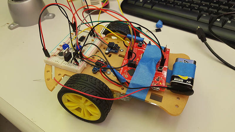
Sound Activated Car
May, 2017
I built this car as a final project for UC Berkeley's EE16B with a partner where
we used different circuit elements such as Resistors, Op-Amps, and Capactiors to build
the hardware and then used Principal Component Analysis (PCA) and Controls
to program the car to respond to voice commands.
Python
Arduino

Google Maps
July, 2016
Used Google Maps API to create my own rendition for the city of Berkeley. Displays
traffic layers, has walking, biking, and transit transportation options, can do
auto-completion when entering place names, finds the shortest path from starting
point to destination, displays step by step directions to destination, and allows
users to zoom in and out of the map.
Java
Javascript
HTML/CSS
Scheme Interpreter
April, 2016
Built an interpreter using the Python language for translating Scheme language code.
Evaluates submitted Scheme expressions.
Python
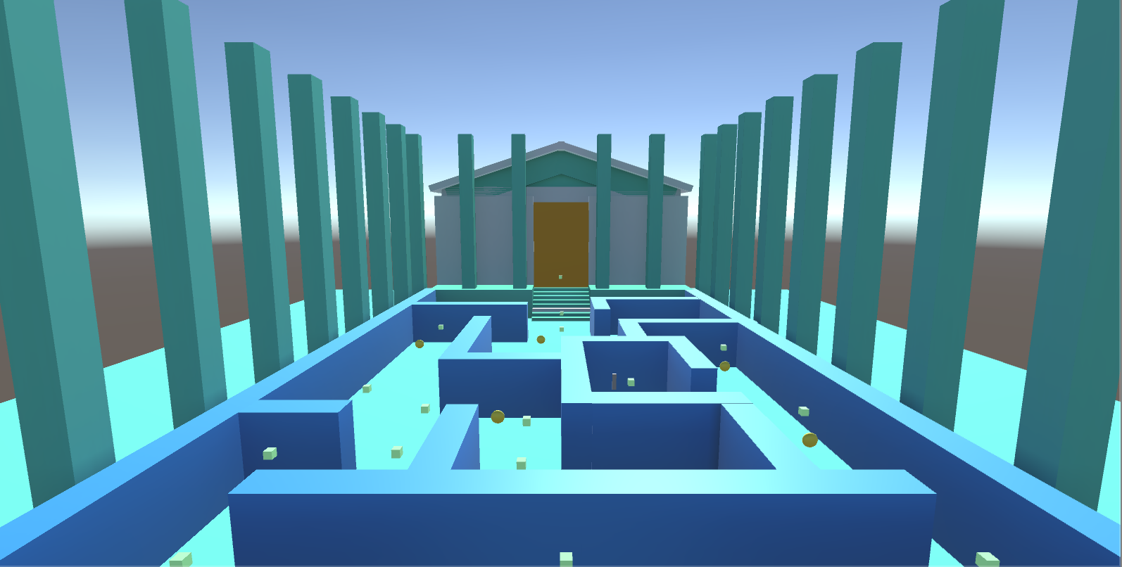
Maze Mobile Virtual Reality Game
December, 2016
Built a mobile Google Cardboard application where players navigate through
a maze using a waypoint-based navigation system in which players "teleport to different
parts of the maze" and collect coins and a key in order to open the gate to win.
C#
Unity Game Engine
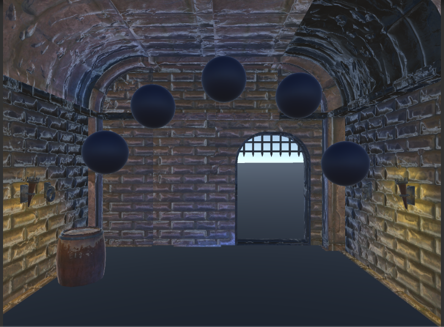
Puzzler Mobile Virtual Reality Game
December, 2016
Built a mobile Google Cardboard application where players navigate through
a puzzle that is adapted from the game Simon Says, which prompts users with an
interface that challenges them to memorize the patterns of lightbulbs flashing
to solve the game.
C#
Unity Game Engine

Organic Chemistry API
November, 2016
Built at Cal Hacks. Built an API which will allow users to use molecular representations for
further projects. Of particular importance is the Molecule class, which stores a collection
of Atoms, linking/bonding them together via a graph data structure. The Molecule class
provides a wide variety of utilities that can be assembled together for more complicated
chemical processing.
Java
GUI